NetCDF
Adding a NetCDF data store
To add a NetCDF data store the user must go to Stores –> Add New Store –> NetCDF.
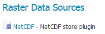
NetCDF in the list of raster data stores
Configuring a NetCDF data store
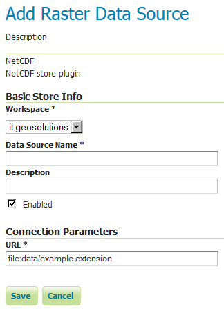
Configuring a NetCDF data store
| Option | Description |
Workspace |
|
Data Source Name |
|
Description |
|
Enabled |
|
URL |
Notes on supported NetCDFs
The NetCDF plugin for GeoServer supports gridded NetCDF files having dimensions following the COARDS convention (custom, Time, Elevation, Lat, Lon).
ToolsUI is an useful java tool developed by UCAR which can be useful for a preliminary check on your dataset. Opening a sample NetCDF using that tool will show an output like this in the Viewer tab:
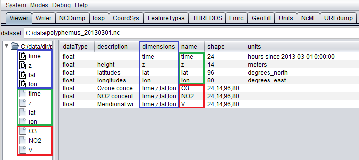
NetCDF viewer in ToolsUI
- This dataset has 4 dimensions (time, z, lat, lon, marked by the D icon in the left side of the GUI. They have been marked by a blue rectangle in the screenshot).
- Each dimension has an associated independent coordinate variable (marked by the green rectangle).
- Finally, the dataset has 3 geophysical variables, marked by a red rectangle, each having 4 dimensions.
The NetCDF plugin supports datasets where each variable’s axis is identified by an independent coordinate variable, as shown in the previous example. Two dimensional non-independent latitude-longitude coordinate variables aren’t currently supported. A coordinate variable like this will be a coordinate variable having 2 dimensions to index it (such as y,x/rows,cols/i,j...). A similar dataset will look like this in ToolsUI. Look at the red marked latitude and longitude coordinate variables, each one identified by a y,x 2D matrix.
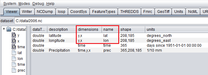
NetCDF viewer in ToolsUI for 2D coordinate variables
Supporting Custom NetCDF Coordinate Reference Systems
Starting with GeoServer 2.8.x, NetCDF related modules (both NetCDF/GRIB store, imageMosaic store based on NetCDF/GRIB dataset and NetCDF output format) allow to support custom Coordinate Reference Systems and Projections. As reported in the NetCDF CF documentation, Grid mappings section a NetCDF CF file may expose gridMapping attributes to describe the underlying projection.
The GeoTools NetCDF machinery will parse the attributes (if any) contained in the underlying NetCDF dataset to setup an OGC CoordinateReferenceSystem object. Once created, a CRS lookup will be made to identify a custom EPSG (if any) defined by the user to match that Projection. In case the NetCDF gridMapping is basically the same of the one exposed as EPSG entry but the matching doesn’t happen, you may consider tuning the comparison tolerance: See Coordinate Reference System Configuration, Increase Comparison Tolerance section.
User defined NetCDF Coordinate Reference Systems with their custom EPSG need to be provided in user_projections\netcdf.projections.properties file inside your data directory (you have to create that file if missing).
A sample entry in that property file could look like this:
971801=PROJCS[“lambert_conformal_conic_1SP”, GEOGCS[“unknown”, DATUM[“unknown”, SPHEROID[“unknown”, 6371229.0, 0.0]], PRIMEM[“Greenwich”, 0.0], UNIT[“degree”, 0.017453292519943295], AXIS[“Geodetic longitude”, EAST], AXIS[“Geodetic latitude”, NORTH]], PROJECTION[“Lambert_Conformal_Conic_1SP”], PARAMETER[“central_meridian”, -95.0], PARAMETER[“latitude_of_origin”, 25.0], PARAMETER[“scale_factor”, 1.0], PARAMETER[“false_easting”, 0.0], PARAMETER[“false_northing”, 0.0], UNIT[“m”, 1.0], AXIS[“Easting”, EAST], AXIS[“Northing”, NORTH], AUTHORITY[“EPSG”,”971801”]]
Note
Note the “unknown” names for GEOGCS, DATUM and SPHEROID elements. This is how the underlying NetCDF machinery will name custom elements.
Note
Note the number that precedes the WKT. This will determine the EPSG code. So in this example, the EPSG code is 971801.
Note
When dealing with records indexing based on PostGIS, make sure the custom code isn’t greater than 998999. (It tooks us a while to understand why we had some issues with custom codes using PostGIS as granules index. Some more details, here)
Note
If a parameter like “central_meridian” or “longitude_of_origin” or other longitude related value is outside the range [-180,180], make sure you adjust this value to belong to the standard range. As an instance a Central Meridian of 265 should be set as -95.
You may specify further custom NetCDF EPSG references by adding more lines to that file.
Insert the code WKT for the projection at the end of the file (on a single line or with backslash characters):
971802=PROJCS["lambert_conformal_conic_2SP", \
      GEOGCS["unknown", \
            DATUM["unknown", \
              SPHEROID["unknown", 6377397.0, 299.15550239234693]], \
        PRIMEM["Greenwich", 0.0], \
            UNIT["degree", 0.017453292519943295], \
            AXIS["Geodetic longitude", EAST], \
            AXIS["Geodetic latitude", NORTH]], \
          PROJECTION["Lambert_Conformal_Conic_2SP"], \
          PARAMETER["central_meridian", 13.333333015441895], \
          PARAMETER["latitude_of_origin", 46.0], \
          PARAMETER["standard_parallel_1", 46.0], \
          PARAMETER["standard_parallel_2", 49], \
          PARAMETER["false_easting", 0.0], \
          PARAMETER["false_northing", 0.0],
          UNIT["m", 1.0], \
          AXIS["Easting", EAST], \
          AXIS["Northing", NORTH], \
          AUTHORITY["EPSG","971802"]]
Save the file.
Restart GeoServer.
Verify that the CRS has been properly parsed by navigating to the SRS page in the Web Administration Interface.
If the projection wasn’t listed, examine the logs for any errors.
Specify an external file through system properties
You may also specify the NetCDF projections definition file by setting a Java system property which links to the specified file.
As an instance: -Dnetcdf.projections.file=/full/path/of/the/customfile.properties