Python Extension Overview
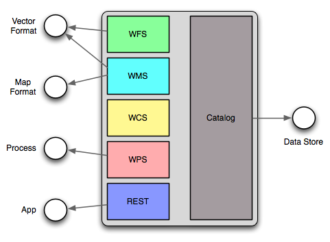
The python extension provides a number of scripting hooks throughout GeoServer. These scripting hooks correspond to GeoServer “extension points”. An extension point in GeoServer is a class or interface that is designed to be implemented and dynamically loaded to provide a specific function. The classic example is a WMS or WFS output format, but GeoServer contains many extension points.
Python scripting extension hooks
Implementing a GeoServer extension point in python involves writing scripts and placing them in the appropriate directory under the GeoServer data directory. When the python extension is installed it creates the following directory structure:
GEOSERVER_DATA_DIR/
   ...
   python/
      app/
      datastore/
      filter/
      format/
      lib/
      process/
Each directory corresponds to a GeoServer extension point.
The app directory consists of python scripts that are intended to be
invoked over HTTP through a wsgi interface.
The datastore directory consists of python modules that implement the
geotools data store interface. The geotools data store interface is the
extension point used to contribute support for vector spatial data formats
ranging from shapefiles to postgis.
The filter directory consists of modules that implement filter
functions. Filter functions are used in WFS queries and in SLD documents.
The format directory consists of modules that implement the various
output format extension points in GeoServer. This includes WMS GetMap,
GetFeatureInfo and WFS GetFeature.
The lib directory contains common modules that can be used in
implementing the other types of modules. These types of modules are typically
utility modules.
The process directory consists of modules that implement the geotools
process interface. Implementations of this extension point are used as processes in
the GeoServer WPS.
Continue to Python Scripting Hooks for more details.